Open Source GIS Platforms
OiPlans delivers a variety of cost-effective services to organizations that are geared to maximizing efficiency by utilizing low-cost open source GIS platforms. We take an innovative approach in providing organizations with a broad selection of client/server architectures, along with specialized support in installing and maintaining enterprise GIS systems.
Supported Applications:
GeoServer is an open-source GIS powerful web mapping and feature server designed to empowering organizations with the capability of effectively share maps and spatial data from a variety of formats.
GeoServer publishes spatial data via Open Geospatial Consortium (OGC) standards such as Web Map Service (WMS) and Web Feature Services (WFS). GeoServer allows organizations to fully integrate with popular mapping applications such as Google Maps, Google Earth, Yahoo Maps, and Microsoft Virtual Earth. With GeoServer organizations can effectively share, create, and edit their spatial data efficiently and cost-effectively.
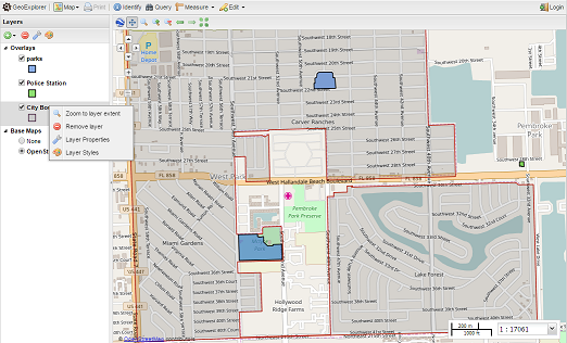
GeoExplorer is an open-source web application designed for creating and publishing maps. With GeoExplorer, organizations can easily build live interactive maps from GeoServer or any OGC Web Mapping Server (WMS) and make them available to the public. GeoExplorer enables organizations to quickly create maps for public consumption by leveraging GeoServer’s web mapping features and integrating with popular maps such as Google Maps and OpenStreetMap.
QGIS is an open-source cross-platform GIS desktop application for viewing, editing, and analyzing geospatial data from a variety of vector, raster, and database formats.
GIS Data Management & Cloud Delivery
The success of Enterprise GIS systems relies greatly on the quality of the underlying data. OiPlans provides professional mapping and data management services including the integration, organization, and storage of GIS data from multiple sources.
OiPlans offers organizations with delivery of GIS services via Cloud. Hosting GIS application services on Amazon’s virtual computing environment maximizes cost-savings to organizations by eliminating costs associated setting up and maintaining in-house dedicated servers.
Services:
- Full installing of either local or cloud-hosted GIS, including ongoing management
- Data loading, including geocoding and geoprocessing services
- Configuration of web-based mapping servers
- Cloud-hosting and management of open source geodatabases and GIS
- Development of specialized features and functions for reporting, workflow and business process